CONSERVATION AREA REPORT
BOW WHARF: THE CHARACTER OF THE CONSERVATION AREA IN THE VICINITY OF THE PROPOSED DEVELOPMENT.
Malcolm Tucker, GLIAS, October 2013
The features at the junction of the Hertford Union Canal with the Regent's Canal make it one of the key points in the heritage of the London canal system. In addition to the junction's intrinsic geographical and historical significance, it retains within a small area several historic structures of types now rare on London's canals.* Their setting retains a relatively low density of built development that was characteristic of the canals of this area until recent years. It also has a fair number of trees, which combine with the small scale of the buildings to produce a calm and pleasant environment and which also form a link both visual and ecological between the public parks to the north and south. The canals of inner London are rapidly becoming dominated by modern waterside developments of a new scale, mostly residential, but of high activity where commercial, so that Bow Wharf provides a now scarce enclave of calm and historic character that it is necessary to protect and sustain.

Aerial photo from south ((c)BLOM and Microsoft Corporation via Bing Maps, 2013)
This aerial photo shows the low building density immediately around the canal junction. Some see in that a prima facie case for development, but this is in a conservation area and it is essential to the character of this part of the area, hence needing protection.
The Regent's Canal Conservation Area Character Appraisal (2009), p.11, remarks that 'The openness or enclosure of sections of the canal should be respected as this contributes to the special character of the various sections along its length. It is important that the existing character is conserved and built upon as far as possible.' (The words 'built upon' must here refer to the character to be consolidated, not land to be developed).
*Cast-iron-girder bridge, stop lock, stoneway, remains of wharf cottages, chimney from sawmill, canal carrier's warehouse.
|
|
As approached from the south-east the site presents a sylvan appearance, almost rural, as it was earlier in the 19th century. Some trees must pre-date the establishment of Mile End Park on the right. It provides continuity between Mile End and Victoria parks. This part of the Regent's Canal Conservation Area is much used and appreciated by the public for recreational purposes. |

|
|
The gable end of the small building adds visual piquancy but does not dominate. This is part of a single-storeyed, mid-C19 row of former cottages, stores and workshops, which belonged to the wharf that handled paving stones. Very much altered, it would seem to be the last such single-storey row remaining on London's canals. |

|
The low densities and the leafy appearance even in early spring are shown in this view across the canal from the south. |

|
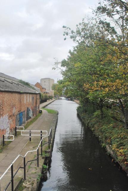
As seen from across the canal, the low-rise buildings and yard demonstrate the traditional character of canalside wharves before the redevelopment wave. |
|
|
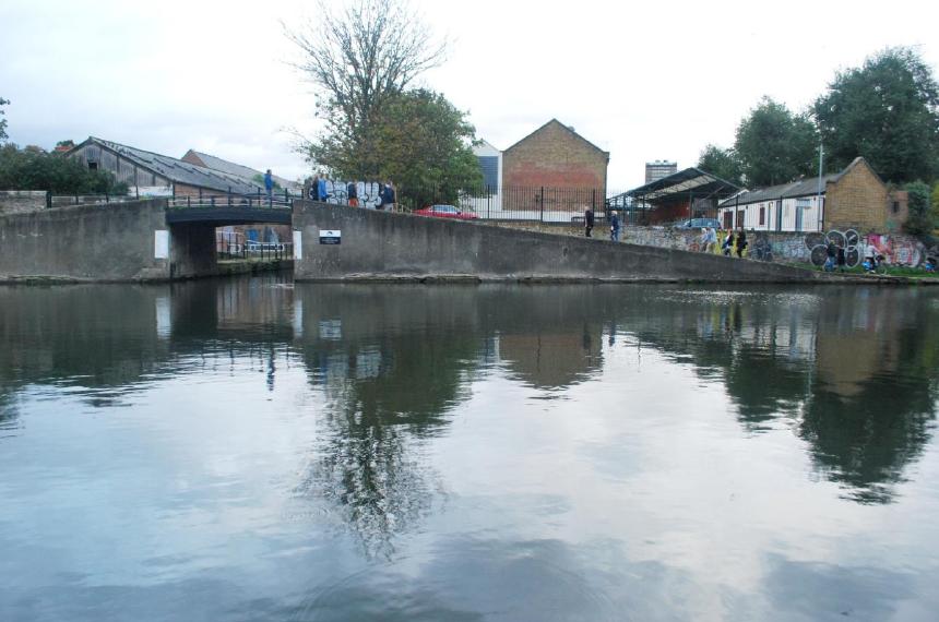
Surrounding the bridge there is plenty of space, allowing this junction of routes and paths to be properly experienced and appreciated by visitors. |

|
Beyond the car park, the row of former cottages and stores was there by 1870. Although much-altered, its origins should make it a positive contributor to the conservation area. It continues in use. |
The placid view from the bridge of the stop lock and the Hertford Union Canal is not yet intruded upon by the cheek-by-jowl balconies of modern housing.
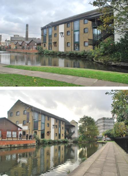
The former canal carrier's warehouse of 1901 rightly dominates the scene. It is one of very few warehouses remaining on London's canals and an excellent example of its type.

The mid-20th-century warehouse by the stop lock is out of use, but it is not an eyesore and its creeper contributes to the greenery. The trees on the opposite bank, of sycamore and ash, have a major landscape function. The distinctive high-rise blocks of Lubetkin's Cranbrook Estate provide an interesting perspective, both visually and historically, while sufficiently distant not to disturb the milieu of Bow Wharf.
SOME VISUAL EFFECTS OF THE PROPOSALS
The following pages been provided to us by supporters of the East End Waterways Group. They compare existing scenes with the architect's visualisations, employing approximately the same angles and positions of view. They illustrate the effects of doubling the building height and enlarging the footprint in Block A, replacing 1 storey by 4 storeys (on a larger footprint) in Block C and building 5 and a half storeys on an open yard in Block B, so as to change the character completely.


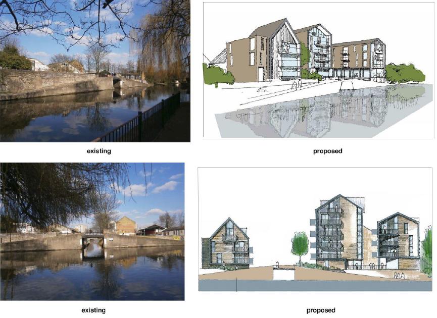

The applicant's perspective visualisations from the Hertford Union Canal of Block B are relatively distant ones, craftily chosen to minimise its size by contrast with the tower blocks beyond and also not showing the balconies:-

However, the north-western elevation in the Design and Access Statement (Part 1, p.23 of 40 on the LBTH website) shows its gross inequality of scale relative to the warehouse of 1901. The replacement tree species close in front would doubtless be selected for limited size and restriction to view and therefore have a poor screening capability:-

With its greater height and array of projecting balconies, this will overwhelm the historic warehouse.
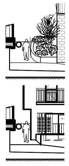
Some problems with Block A
|
This shows the sharp increase in the height of the skyline relative to the Regent's Canal towpath. The proposed building (Block A) is much closer to the towpath than the existing building. 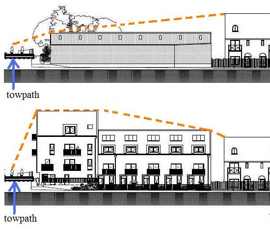
|
This shows the architect's justification for stepping up the height of the building nearest the Regent's Canal. "Due to the height at bridge level, the front of Block A will give the impression of a two storey block with third floor in the roof". 
|

|
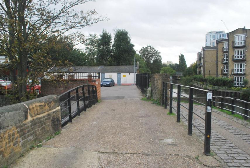
This shows the significant narrowing of the space available on the ramp that joins Regent's Canal towpath to the Hertford Union Canal towpath. Although the width of the path will probably remain the same, the proximity of the building will change drastically. |
|
When the existing warehouse was built probably in the 1930s on previously open land, its south-western end left a broad ramp down to the lockside, wide enough for vehicles. That ramp was narrowed by a landscaping feature a few years ago (see earlier photo). The proposed building encroaches across that feature at ground floor level, jetties over the pathway at first floor and then thrusts out balconies at 2nd and third floors. These will bring the gable end closer to the Regent's Canal, exacerbating the effects of the doubled building height and increased building width in making this building very prominent and intrusive on the existing character