Blue Ribbon Network
The full London Plan document (dated March 2015) is available here in PDF format (approx 39MB) and for convenience some extracts from the Blue Ribbon policies (pages 313 to 325) are provided below
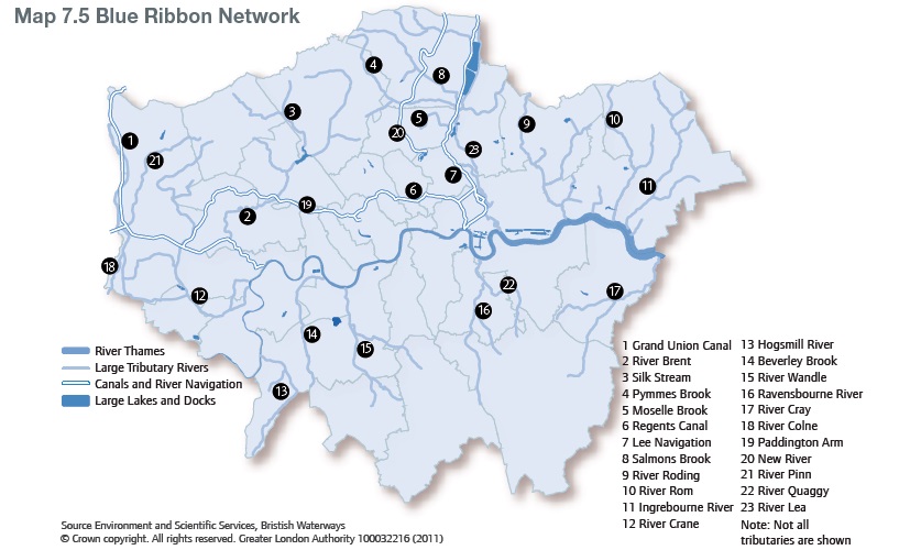
7.70 The Blue Ribbon Network (BRN) is London's strategic network of waterspaces (see Map 7.5) and covers the River Thames, canals, tributary rivers, lakes, reservoirs and docks alongside smaller waterbodies. The network is of cross cutting and strategic importance for London; every London borough contains some element of the network - 17 border the Thames and 15 contain canals. The nature of waterbodies is that there are linked, natural or semi natural systems, therefore the concept of the network is of vital importance.
See Policy 7.24 - Blue Ribbon Network
7.71 The Blue Ribbon Network is multifunctional. It provides a transport corridor, drainage and flood management, a source of water, discharge of treated effluent, a series of diverse and important habitats, green infrastructure, heritage value, recreational opportunities and important landscapes and views. The starting point for consideration of development and use of the Blue Ribbon Network and land alongside it must be the water. The water is the unique aspect and consideration must initially be given as to how it can be used, maintained and improved.
7.72 The Environment Agency has published the first Thames River Basin Management Plan. This covers all the waterbodies within London. It includes actions, which aim to improve their ecological status and potential (see paragraph 5.58).
See Policy 7.25 - Increasing the use of the Blue Ribbon Network for passengers and tourism
7.73 On the navigable parts of the network, the Mayor wishes to ensure that uses of the water and land alongside it are prioritised, within sustainable limits, for transport purposes - both passenger and freight. By reducing demand for other forms of surface transport, particularly on roads, the benefits of water transport link through to other key aspects of this Plan, notably climate change mitigation and improving the quality of life. For too long these uses have been marginalised and compromised by competing developments. In some cases higher value developments have squeezed out landward facilities, in other cases waterborne developments such as permanent moorings have restricted the speed or berthing abilities for transport craft. Recent years have seen substantial growth in the use of passenger services on the Thames. This followed investment in piers by Transport for London and investment in vessels by private operators. The Mayor is keen to see continued growth to maximise the use of the Thames for river travel. Transport for London's River Action Plan outlines a number of specific measures including the establishment of new piers along the Thames and the delivery of additional capacity at a number of Central London piers specifically to address congestion.
7.74 In 2009 the GLA and LDA commissioned research into cruise liner facilities. This demonstrated that a suitable terminal facility in London would be expected to attract a significant increase in cruise ship visits. This would also boost the profile of London and help to diversify the economy. In practice there are a limited number of locations where a cruise terminal would be viable. The Mayor will work with strategic partners including appropriate boroughs to identify suitable opportunities over the period of the Plan.
See Policy 7.26 - Increasing the use of the Blue Ribbon Network for freight transport
7.75 Using water based transport for freight is fully in line with the NPPF, in particular paragraphs 29, 30 and 41, promoting sustainable modes of transport and paragraph 143 specifically referring to the safeguarding of wharfage to facilitate minerals handling. Water transport is recognised as one of the most sustainable modes, particularly for low value, non time-critical bulk movements.
7.76 The safeguarding of a number of wharves is a well-established aspect of planning in London. The safeguarding directions, some of which have been in existence since 1997, have successfully maintained a number of sites which can now be used to transport goods through London. The Mayor will support positive action, including the use of compulsory purchase powers where necessary, to bring inactive sites into use. The specific sites that are safeguarded are set out in the Safeguarded Wharves Implementation Report January 2005. Appropriate access to the highway network and relevant freight handling infrastructure such as jetties should also be protected. The safeguarding will be reviewed and updated approximately every five years. The next review will look at opportunities to consolidate wharves, expand the use of water freight and consider whether it is appropriate to safeguard any wharf facilities on London's canal network.
7.77 The redevelopment of safeguarded wharves should only be accepted if the wharf is no longer viable or capable of being made viable for waterborne freight handling uses. The only exception to this would be for a strategic proposal of essential benefit for London, which cannot be planned for and delivered on any other site in Greater London. The viability of a wharf is dependent on:
- its size, shape, navigational access, road access, rail access (where possible), planning history, environmental impact and surrounding land use context
- its geographical location, in terms of proximity and connections to existing and potential market areas
- the existing and potential contribution it can make towards reducing road based freight movements
- existing and potential relationships between the wharf and other freight handling sites or land uses
- the location and availability of capacity at comparable alternative wharves, having regard to current and projected Port of London and wharf capacity and market demands.
7.78 Appropriate temporary uses on vacant safeguarded wharves can ensure that investment in the wharf is maintained and image problems are minimised for the wider area. Temporary uses must maintain the existing freight handling infrastructure to a specified standard, be limited by a temporary permission with a specific end date and priority should be given to uses which require a waterside location. Temporary uses should not be permitted where a permanent freight handling use is available.
7.79 Some wharves are increasingly surrounded by different land uses that do not have an industrial or freight purpose. Many wharves are in the opportunity areas identified in Chapter 2. The challenge is to minimize conflict between the new and the old land uses. This must be met through modifications and safeguards built into new and established developments. Wharf operators should use appropriate available means to mitigate the environmental impacts of freight handling. New development next to or opposite wharves should utilise the layout, use and environmental credentials of buildings to design away these potential conflicts. Appropriate highway access to wharves for commercial vehicles needs to be maintained when considering proposals for development of neighbouring sites.
See Policy 7.27 - Blue Ribbon Network: supporting infrastructure and recreational use
7.80 In order to make the maximum use of the Blue Ribbon Network, particularly for effective transport, a range of supporting infrastructure is required. The infrastructure includes, but is not limited to; boatyards, jetties, moorings, slipways, steps and water side paths/cycleways. Their need and provision should be assessed by local authorities.
7.81 The Mayor commissioned research in 2007 to investigate the provision of boatyards in London. From this it is clear that there is a particular shortage of boatyard facilities that are capable of inspecting, maintaining and repairing the larger passenger craft on the Thames. One of the actions in the Implementation Plan (see Chapter 8) will be to promote such a new facility.
7.82 Similarly, the historic steps and slipways to the Thames foreshore are often overlooked, neglected or even removed. These facilities are vital for enabling access to the Thames foreshore given the huge tidal range of the river and the Mayor wishes to see these facilities retained, improved and where disused, brought back into use.
7.83 The promotion of the use of the Blue Ribbon Network for leisure facilities is an important objective. Water provides opportunities for particular types of leisure and sporting activities such as rowing, canoeing and sailing. Water-based sport and recreation should be prioritized and facilities that enable or enhance these activities should be supported.
7.84 The range of permanently moored vessels, for example residential barges, restaurants, bars and offices can add to the diversity and vibrancy of waterways and London in general. However, their siting needs careful consideration so that the navigation, hydrology and biodiversity of the waterways are not compromised. Consents for and the use of new moorings should be managed in a way that respects the character of the waterways and the needs of its users. The BRN should not be used as an extension of the developable land in London nor should parts of it be a continuous line of moored craft.
See Policy 7.28 - Restorat ion of the Blue Ribbon Network
7.85 London's rivers have been hugely altered from their natural state. This has generally had the effect of reducing their value to wildlife, and often amenity too (see also policies 2.18 and 7.19). Ultimately this has resulted in the complete loss of rivers such as the Fleet, Tyburn or Effra which now form part of the city's sewerage network. This cannot be allowed to continue and a strong policy direction is needed to reverse previous unsustainable alterations. The improvement of waterbodies to 'good ecological/potential' and not allowing any deterioration in the status of water bodies are key requirements of the Water Framework Directive (see Policy 5.14). In particular, pollution from vessels should also be minimised.
7.86 A partnership led by the Environment Agency has produced a River Restoration Action Plan. This database sets out the location of opportunities to restore and enhance the Blue Ribbon Network. Some of these will be implemented through capital projects and some through nearby redevelopments. The database is reviewed regularly and interactively invites suggestions for further restoration projects.
See Policy 7.29 - The River Thames
7.87 The River Thames is one of London's icons and merits special attention. The river changes a great deal in its size and character as it flows through London, particularly given the twice daily changes brought by the tidal nature of the river.
7.88 The central London stretches of the Thames are world famous locations, featuring well known landmarks and views. Many other stretches have important historic, cultural and natural connections. These aspects of the Thames should be protected.
7.89 As outlined in policies 7.25-7.27, there are opportunities to increase the role that the Thames plays in transport terms. The Mayor believes that river transport should be increased within sustainable limits, and that owners and users of riverside sites should consider how they could contribute to or benefit from river transport.
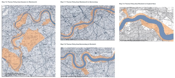
7.90 The Thames is a borough boundary for the vast majority of its length, therefore coordinated planning approaches are essential. The Thames Policy Area is a well established tool for ensuring this co-ordination. Setting the boundary of the Thames Policy Area should be done in consultation with neighbouring authorities, including those across the river. In defining the boundaries, boroughs should have regard to maps 7.6-7.9 at the end of this chapter and the following criteria:
- proximity to the Thames, including its tributaries and associated areas of water such as docks, canals, filter beds and reservoirs, whether or not directly linked to the Thames, but where an association with the Thames is retained together with a proportion of open water
- contiguous areas with clear visual links between areas/buildings and the river, including views from across the river and areas where it may be beneficial to establish future visual links
- specific geographical features - such as main roads, railway lines, hedges, identified as particularly relevant for defining the boundary across large open spaces
- the whole curtilage of properties or sites adjacent to the Thames, except where major development sites have been identified and it is intended to publish master plans/ strategies for future development
- areas and buildings whose functions relate or link to the Thames and/or river-related uses or sites that have the potential to be linked
- areas and buildings that have an historic, archaeological or cultural association with the Thames, including planned vistas marked by existing or former landscape features
- boundaries should have coherence with neighbouring authorities.
7.91 Boroughs are encouraged to carry out appraisal, Thames Policy Area designation and policy and strategy formulation in collaboration with other boroughs, and relevant stakeholders. There are three existing partnerships within London that have delivered strategies for the Thames in their stretches of the river. These are:
- Thames Strategy Hampton-Kew
- Thames Strategy Kew-Chelsea
- Thames Strategy East
7.92 These strategies provide a good sub-regional context in which decisions relating to the planning and management of the river can be set. Furthermore, all of the strategies are supported by the key regional/national stakeholders. The Mayor encourages all of the relevant boroughs to participate in the strategies and for the boroughs between Vauxhall Bridge and Tower Bridge to take a similar sub-regional overview of their high profile stretch of the Thames.
7.93 The strategies should be reviewed regularly and would be expected to consider:
- the local character of the river
- water-based passenger and freight transport nodes (both existing and potential)
- development sites and regeneration opportunities
- opportunities for environmental and urban design improvements
- sites of ecological or archaeological importance
- areas, sites, buildings, structures, landscapes and views of particular sensitivity and importance
- focal points of public activity
- public access
- recreation and marine infrastructure
- indicative flood risk.
7.94 They should also identify areas of deficiency, and the actions needed to address these deficiencies, through facilities for:
- water-based passenger, tourism and freight transport
- water-based sport and leisure
- access and safety provision
- marine support facilities and infrastructure and moorings.
7.95 The strategies should be used as guidance for LDFs and development control decisions. They also include specific implementation projects for local authorities and other organisations in a position to implement river-related projects. They should also be used to identify important riverside sites and determine the river-related expectations for them. As such, the strategies should be expressed through DPD policies or SPD as appropriate.
7.96 As part of major development proposals for sites with a Thames frontage, consideration should be given to the need and desirability of having facilities to enable access to and from the river, both for boats and for pedestrians. This may include the retention, refurbishment or reinstatement of existing or former access points or the provision of new facilities. Along the Thames in east London there are locations where a large amount of development is envisaged in opportunity areas. Some of these locations offer the opportunity for creating significant public open spaces, which should be pursued. These may be dovetailed with the need to allow a margin of land for future flood defences.
7.97 In some parts of London the Thames is designated as open space, for example as Metropolitan Open Land or falls within conservation areas. In areas where it is likely to be feasible to increase transport use of the river, such designations need careful consideration such that they do not hinder or prevent the development of and improvements to these waterbased uses.
7.98 During the lifetime of this London Plan the Thames Tideway Sewer Tunnels will be constructed (see Policy 5.14). These should be designed to minimise impacts on the river, maximise water based freight and consider permanent uses for any required infrastructure such as jetties.
See Policy 7.30 - London's canals and other rivers and waterspaces
7.99 London's wide diversity of water spaces that constitute the Blue Ribbon Network require a careful approach to their planning and management. Rivers, lakes and ponds are heavily affected by natural forces such as flooding and erosion, even manmade canals and reservoirs are affected to some degree. It is important to see these as dynamic systems and ensure that development in or close to the network respects its particular characteristics (see also policies 5.12-5.15). There are some aspects of the management of the Blue Ribbon Network - cleaning of rivers, for example, where lines of responsibility are blurred. The Mayor will work with the relevant organisations to seek to clarify these responsibilities.
7.100 The Mayor places great emphasis on ensuring that new development utilises the water space; primarily for transport purposes where that is possible, but also for active water based leisure, for informal waterside recreation or access, for regeneration purposes through water-related development, and for the protection and enhancement of biodiversity. The facilities supporting recreational use mentioned in Policy 7.27 have significant value on canals supporting the visitor economy.
7.101 The Blue Ribbon Network is also a valuable educational resource and several organisations have been established which specifically promote water-based educational programmes. The Blue Ribbon Network is often an appropriate setting for public art and performance. People generally like to gather by the waterside and opportunities for this should be encouraged.
7.102 The Mayor is particularly mindful that the very nature of the Blue Ribbon Network is that it flows into London from adjoining regions and that the Thames flows out of London in the two adjoining regions. Communication across regional and local authority boundaries will be important to sustainable management of the system.
Royal Docks
7.103 The size and scale of the water spaces of the Royal Docks are unique in London and form an important part of the character and distinctiveness of east London. Improving public access to and activity on these water spaces can support the regeneration of the surrounding area and contribute to the creation of new jobs and homes. To help achieve this, development into parts of these water spaces may facilitate this transformation, provided that any such development maintains the visual integrity, openness and historic character of the relevant dock and provided that navigation, hydrology, flood risk management and biodiversity are not compromised.
7.104 London City Airport places significant demands on London's public transport system and strategic road network. The Mayor will therefore work with the airport's owners and operators, relevant boroughs and other partners to explore how passengers and staff could make better use of London's waterways; for example by establishing direct river boat connections to central London and Canary Wharf, and providing, connecting to, or contributing to piers and services.
POLICY 7.24 BLUE RIBBON NETWORK
A - Strategic
The Blue Ribbon Network is a strategically important series of linked spaces. It should contribute to the overall quality and sustainability of London by prioritizing uses of the waterspace and land alongside it safely for water related purposes, in particular for passenger and freight transport. Regard should be paid to the Thames River Basin Management Plan and the emerging marine planning regime and the Marine Policy Statement.
POLICY 7.25 INCREASING THE USE OF THE BLUE RIBBON NETWORK FOR PASSENGERS AND TOURISM
A - Strategic
The Mayor will seek to increase the use of the Blue Ribbon Network for passenger and tourist river services, and supports the principle of additional cruise liner facilities on the Thames.
B - Planning decisions
Development proposals: (a) should protect existing facilities for waterborne passenger and tourist traffic. Applications which remove existing facilities should be refused unless suitable replacement facilities are provided
(b) which provide new facilities for passenger and tourist traffic, especially on the central London stretch of the River Thames will be supported
(c) which provide improved facilities for cruise ships in London will be supported.
C - LDF preparation
Within LDFs boroughs should identify locations that are suitable for passenger, tourist or cruise liner facilities.
POLICY 7.26 INCREASING THE USE OF THE BLUE RIBBON NETWORK FOR FREIGHT TRANSPORT
A - Strategic
The Mayor seeks to increase the use of the Blue Ribbon Network to transport freight.
B - Planning decisions
Development proposals:
(a) should protect existing facilities for waterborne freight traffic, in particular safeguarded wharves should only be used for waterborne freight handling use. The redevelopment of safeguarded wharves for other land uses should only be accepted if the wharf is no longer viable or capable of being made viable for waterborne freight handling, (criteria for assessing the viability of wharves are set out in paragraph 7.77). Temporary uses should only be allowed where they do not preclude the wharf being reused for waterborne freight handling uses (see paragraph 7.78). The Mayor will review the designation of safeguarded wharves prior to 2012.
(b) which increase the use of safeguarded wharves for waterborne freight transport, especially on wharves which are currently not handling freight by water, will be supported
(c) adjacent or opposite safeguarded wharves should be designed to minimise the potential for conflicts of use and disturbance
(d) close to navigable waterways should maximize water transport for bulk materials, particularly during demolition and construction phases.
C - LDF preparation
Within LDFs boroughs should identify locations that are suitable for additional waterborne freight.
POLICY 7.27 BLUE RIBBON NETWORK: SUPPORTING INFRASTRUCTURE AND RECREATIONAL USE
A - Planning decisions
Development proposals should enhance the use of the Blue Ribbon Network, in particular proposals:
(a) that result in the loss of existing facilities for waterborne sport and leisure should be refused, unless suitable replacement facilities are provided
(b) should protect and improve existing access points to (including from land into water such as slipways and steps) or alongside the Blue Ribbon Network (including paths). New access infrastructure into and alongside the Blue Ribbon Network will be sought.
(c) should protect and enhance waterway support infrastructure such as boatyards, moorings, jetties and safety equipment etc. New infrastructure to support water dependent uses will be sought. New mooring facilities should normally be off line from main navigation routes, ie in basins or docks.
B - LDF preparation
Within LDFs boroughs should identify the location of waterway facilities and any opportunities for enhancing or extending facilities, especially within opportunity areas and other areas where a particular need has been identified.
POLICY 7.28 RESTORATION OF THE BLUE RIBBON NETWORK
A - Planning decisions
Development proposals should restore and enhance the Blue Ribbon Network by:
(a) taking opportunities to open culverts and naturalise river channels
(b) increasing habitat value. Development which reduces biodiversity should be refused
(c) preventing development and structures into the water space unless it serves a water related purpose (see paragraph 7.84).
(d) protecting the value of the foreshore of the Thames and tidal rivers
(e) resisting the impounding of rivers
(f) protecting the open character of the Blue Ribbon Network.
B - LDF preparation
Within LDFs boroughs should identify any parts of the Blue Ribbon Network where particular biodiversity improvements will be sought, having reference to the London River Restoration Action Plan (see paragraph 7.86).
POLICY 7.29 THE RIVER THAMES
A - Strategic
The River Thames is a strategically important and iconic feature of London. This role should be protected and promoted.
B - Planning decisions
Development proposals within the Thames Policy Area identified in LDFs should be consistent with the published Thames Strategy for the particular stretch of river concerned.
C - LDF preparation
Following appraisal in accordance with the criteria in paragraph 7.90 Thames-side boroughs should identify a Thames Policy Area within their LDFs and formulate policies and a strategy for this area covering the matters set out in paragraphs 7.93 and 7.94. Boroughs are encouraged to work in subregional partnerships to progress this work. The existing Thames Strategies have identified a range of actions and planning priorities that should be reflected in relevant LDFs.
POLICY 7.30 LONDON'S CANALS AND OTHER RIVERS AND WATERSPACES
A - Planning decisions
Development proposals along London's canal network and other rivers and waterspace (such as reservoirs, lakes and ponds) should respect their local character and contribute to their accessibility and active water related uses, in particular transport uses, where these are possible.
B - Planning decisions
Development within or alongside London's docks should protect and promote the vitality, attractiveness and historical interest of London's remaining dock areas by:(a) preventing their partial or complete in-filling (see paragraph 7.103)
(b) promoting their use for mooring visiting cruise ships and other vessels
(c) encouraging the sensitive use of natural landscaping and materials in and around dock areas
(d) promoting their use for water recreation
(e) promoting their use for transport
C - LDF preparation
Within LDFs boroughs should identify any local opportunities for increasing the local distinctiveness and use of their parts of the Blue Ribbon Network