
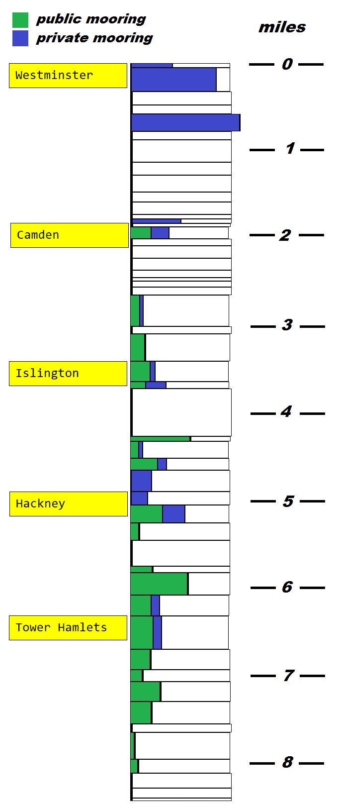
Mooring Density
The chart below is a rough guide to the density of moored boats along the Regent's Canal. It is based on sightings in March 2017. The canal dimensions are derived from Alan Faulkner's book "The Regent's Canal - London's Hidden Waterway"
The table below is a rough guide to the number of moored boats that can be accommodated on the Regent's Canal.
yds = length of canal stretch in yards
TC = towpath casual moorings (assume single mooring)
TV = towpath visitor moorings
TP = towpath private moorings
OC = offside casual moorings
OV = offside visitor moorings
OP = offside private moorings
| yds | TC | TV | TP | OC | OV | OP | |
|---|---|---|---|---|---|---|---|
| Harrow Road to Warwick Road | 90 | 5 | |||||
| Warwick Road to Edgware Road | 480 | 37 | 18 | ||||
| Edgware Road to Maida Hill Tunnel | 270 | ||||||
| Maida Hill Tunnel to Lisson Grove | 185 | ||||||
| Lisson Grove to footbridge | 350 | 51 | |||||
| footbridge to Park Road | 175 | ||||||
| Park Road to Charlbert Bridge | 455 | ||||||
| Charlbert Bridge to Macclesfield Bridge | 260 | ||||||
| Macclesfield Bridge to Primrose Hill Bridge | 340 | ||||||
| Primrose Hill Bridge to Zoo footbridge (W) | 205 | ||||||
| Zoo footbridge (W) to Zoo footbridge (E) | 250 | ||||||
| Zoo footbridge (E) to St Marks bridge | 90 | ||||||
| St Marks bridge to Prince Albert Road | 90 | 5 | |||||
| Prince Albert Road to Regents Park Road | 75 | ||||||
| Regents Park Road to Gloucester Ave | 245 | 7 | 6 | ||||
| Gloucester Ave to Oval Rd | 145 | ||||||
| Oval Rd to Camden High St | 255 | ||||||
| Camden High St to Kentish Town Rd | 240 | ||||||
| Kentish Town Rd to Camden St | 150 | ||||||
| Camden St to Camden Rd | 70 | ||||||
| Camden Rd to Royal College Street | 125 | ||||||
| Royal College Street to St Pancras Way | 160 | ||||||
| St Pancras Way to Camley Street bridge | 630 | 8 | 3 | ||||
| Camley Street bridge to St Pancras Lock | 150 | ||||||
| St Pancras Lock to York Way | 555 | 5 | 6 | ||||
| York Way to Caledonian Road | 410 | 11 | 3 | ||||
| Caledonian Road to Muriel Street | 145 | 3 | 4 | ||||
| Islington Tunnel | 960 | ||||||
| Colebroke Row to Danbury Street | 100 | 8 | |||||
| Danbury Street to Wharf Road | 345 | 4 | 2 | ||||
| Wharf Road to Packington bridge | 245 | 9 | 3 | ||||
| Packington bridge to New North Road | 430 | 12 | |||||
| New North Road to Bridport Road | 270 | 6 | |||||
| Bridport Road to Whitmore Road | 365 | 16 | 11 | ||||
| Whitmore Road to Kingsland Road | 350 | 4 | |||||
| Kingsland Road to Haggerston bridge | 520 | 1 | |||||
| Haggerston bridge to Queensbridge Road | 135 | 4 | |||||
| Queensbridge Road to Goldsmith Road | 455 | 23 | 12 | ||||
| Goldsmith Road to Mare Street | 425 | 12 | 5 | ||||
| Mare Street to Bonner Bridge | 675 | 21 | 8 | ||||
| Bonner Bridge to Old Ford Road | 410 | 11 | |||||
| Old Ford Road to Roman Road | 245 | 4 | |||||
| Roman Road to footbridge | 400 | 16 | |||||
| footbridge to Mile End Road | 455 | 13 | |||||
| Mile End Road to Solebay Street | 170 | ||||||
| Solebay Street to Rhodeswell Road | 545 | 1 | 2 | ||||
| Rhodeswell Road to railway bridge | 285 | 3 | |||||
| railway bridge to Salmon Lane | 305 | ||||||
| Salmon Lane to Commercial Road | 200 | ||||||
| Commercial Road to Limehouse | 60 | ||||||
| Totals | 14945 | 169 | 17 | 93 | 6 | 0 | 98 |